

Federal, State Agency Collaboration Speeds Recovery From Baltimore’s Key Bridge Collapse
WASHINGTON — Transportation Secretary Pete Buttigieg remembers Monday, March 25, as being like any other night.
The last thing he did before going to sleep that night was put his cellphones on a dresser across from his bed, “so I’m not tempted to keep myself awake scrolling,” he told the attendees at the recent Semafor World Economy Summit.
“Of course, as I pulled up the sheets, I thought, ‘Did I turn the ringer on on my work phone?’ So I got back out of bed, walked across the room and turned the ringer on,” he continued, laughing along with his audience at life’s little moments.
“Of course, in the middle of the night, the call came,” he said.
The call, of course, was about a serious, almost unbelievable mishap just 45 miles away.
At 1:25 a.m. on the morning of March 26, the Dali, a massive cargo ship laden with over 4,000 containers bound for Sri Lanka from the Port of Baltimore, experienced a complete loss of power when the electrical breakers that fed most of the vessel’s equipment and all of its lighting suddenly tripped.
With the Dali’s pilots suddenly without any ability to steer the ship and its diesel engine idled, the ship started veering to its right.
Though crew members scrambling in the dark were able to restore electricity by manually closing the tripped breakers, it was only a momentary reprieve — long enough for the pilot’s dispatcher to notify the U.S. Coast Guard and Maryland Transportation Authority Police that a crisis was transpiring, but little more.
A moment later, as tugboats raced toward the Dali in a desperate attempt to steady it, the cargo ship lost power again.
Now less than a quarter mile from the Francis Scott Key Bridge, the crew once again scrambled to close the breakers; this time, however, their efforts couldn’t stave off a disaster.
By the time the lights came on a second time, it was clear the Dali was on a collision course with the bridge and there was nothing anybody could do about it. The pilot’s dispatcher made a mayday call that enabled police to stop traffic to the bridge.
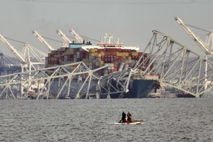
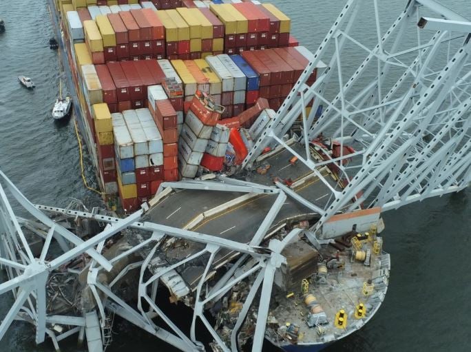
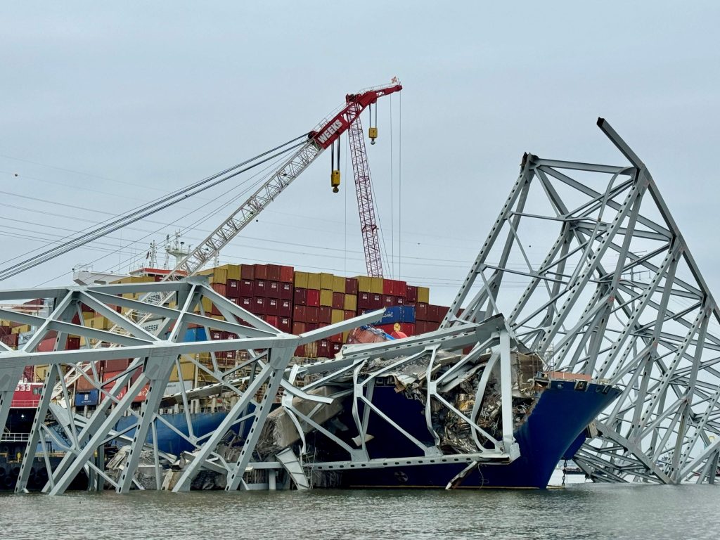
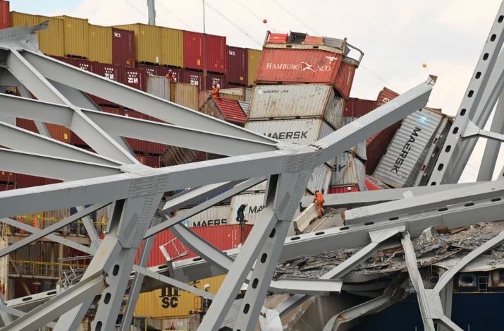
Then, at 1:29 a.m., the Dali struck a key support of the bridge, causing the 1.6-mile steel span to crash down into the Patapsco River. Six road workers sitting in their vehicles on a break were swept to their deaths.
Another member of the crew survived by managing to free himself from his truck after it sank into the swirling waters. A road maintenance inspector also survived by running to safety in the few short seconds between the collision and the failure of the bridge.
“The next thing you know, I’m talking to my team, I’m talking to Maryland Gov. Wes Moore, I’m talking to the White House … doing the part of my job that’s about contending with things that happen,” he said.
Because that part of Buttigieg’s job often garners headlines — whether it’s dealing with the collapse of the Key Bridge, a blown door panel on an Alaska Airlines flight or the temporary closure of Interstate 95 following the explosion of a tanker truck — the reality is the Transportation Department is not, by design, an entity that engages primarily in emergency management.
“Our charge is to be thinking about transportation in the longest terms, and building things,” Buttigieg said. “We have to make sure we can contend with emergencies when they arise, but our goal is to have that account for 49% or less of our time and attention.”
In reality, the transportation secretary said, the successful recovery from something like the loss of the Key Bridge “is all about the handshake between the state and the federal [government] … because we don’t run railroads, we regulate them. We don’t run highways and bridges, we fund them.
“So the puzzle is always, how do we take all of the pulleys and levers of the government, the formal ones and informal ones, and use them to help the people who are on the ground,” Buttigieg said.
The morning after the bridge disaster, President Joe Biden called on Congress to authorize the federal government to pay for 100% of the cleanup of the accident and reconstruction of the bridge — an outcome that’s still uncertain due to resistance from some congressional Republicans.
But even before the president spoke, the U.S. Coast Guard was on the scene, coordinating an effort that involved 53 different federal, state and local agencies.
In all, said Bobby Petty, the Unified Command public affairs officer for the U.S. Army Corps of Engineers, more than 130 vessels and 900 workers “in all types of jobs” spread over a roughly 14-square-mile area of Baltimore Harbor to see that the Port of Baltimore was reopened as quickly and safely as possible, while also setting the stage for the raising of a new bridge.
So successful were these efforts that on April 25, a day shy of a month after the Dali crash and bridge collapse, the Balsa 94, a bulk carrier, became the first cargo ship to pass through a temporary deep-water channel through the area and proceed from Baltimore to Saint John, New Brunswick, Canada.
Two more commercial vessels followed, and the 35-foot-deep channel has been in almost daily use ever since, much to the relief of the truckers, stevedores, longshoremen and thousands of small business owners impacted by the accident.
In late May, the first cruise ship will call on the port since the bridge collapse, marking another major milestone.
The swift progress of the recovery team, which also includes the U.S. Army Corps of Engineers, the National Oceanic and Atmospheric Administration and others, also imbued the state of Maryland with the confidence to announce plans to rebuild the Francis Scott Key Bridge in just over four years at an estimated cost between $1.7 billion and $1.9 billion.
If all goes according to plan, the Maryland Department of Transportation believes drivers will be crossing the new span by the fall of 2028.
All-of-Government Response Marked by Strong Collaboration
To understand why the departmental and agency response was so successful one first needs a little context.
In federally regulated navigable waterways, many government agencies share responsibilities to achieve a common goal — a safe, resilient and efficient marine transportation system for the United States.
In terms of their shared authority, the U.S. Coast Guard is responsible for marking navigable waterways with aids to navigation and informing the maritime public when hazards are present.
Along with these duties, the U.S. Coast Guard “Captain of the Port” has the authority to open and close ports as conditions warrant.
For those unfamiliar with the term, the captain of the port is typically the U.S. Coast Guard sector commander, and charged with enforcing their respective area’s port safety and security and marine environmental protection regulations, including those related directly to the protection and security of vessels, harbors, and waterfront facilities, as well as security and safety zones.
The U.S. Army Corps of Engineers is responsible for surveying and dredging the federal channel — the navigable passage in coastal waterways used for economic and national security purposes and keeping it clear of hazards.
The National Oceanic and Atmospheric Administration is responsible for surveying the undersea environment outside the federal channel and charting all navigable waters.

In addition to the federal partners, the unified command for the Key Bridge disaster response includes representatives of the Maryland Transportation Authority and the Maryland State Police.
“As a basic rule of thumb, think of the Coast Guard as being in charge of everything above the water, and entities like the Army Corps and NOAA being responsible for what lies beneath the water,” one official said.
From the moment they arrived on the scene, all of the entities were engaged in a Coast Guard led effort to safely restore the maritime transportation system in and out of Baltimore Harbor; minimize the environmental impact of the incident, including potential pollution hazards; assess the damage to the Dali, which was covered with an estimated 3,000 to 4,000 tons of steel and concrete after a portion of the bridge landed on the ship’s deck; implement salvage plans for the Dali and the bridge wreckage, and finally, support investigative efforts into the cause of the incident.
Officials The Well News spoke with on background about the response effort repeatedly referred to both the uniqueness of the incident — most port closures in recent memory have been hurricane-related — and the need for the effort partners to get in sync as quickly as possible.
One recalled how they’d worked “at least eight incidents in the last four years,” but in every one of those cases, the lead agency was the Federal Emergency Management Agency.
“So there’s a learning curve when the lead agency is someone else, as in this case with the Coast Guard, where you have to learn the rank structure, etc., but that’s really the simple stuff,” this individual said.
“What’s far more crucial is learning how the lead agency and other partners in the effort communicate, that’s really what the focus is on,” they added.
To illustrate the level of teamwork among the recovery partners, another official pointed to the contractors on this site.
“Oftentimes, prime contractors are very competitive — especially during the winter months, when contracts are scarcer,” they observed. “You might even see situations where contractors working the same job might intentionally do things to make the other companies look bad.
“There has been none of that when it comes to this recovery effort,” they continued. “Everyone has pulled together to get this done as quickly and efficiently as possible.”
“There’s been a supreme focus on the end goal of removing the bridge debris, getting the Dali back to port and returning the area back to the local authorities so they can figure out what the next step is in terms of getting things back to normal,” yet another official said.
Software Playing Key Role in Recovery Effort
While human might, muscle and selflessness is one part of the recovery effort story, another key element in its rapid progress has been the various responding entities’ ability to share data at a digital level rapidly and efficiently.
Officials with the Coast Guard, NOAA and the Army Corps all agreed that data sharing quickly enabled the whole-of-government approach to responding to the mishap to be expanded to a whole-of-community approach.
And the critical element here, all agreed, was how they’ve been able to rely on GIS data — identifying sometimes rapidly changing underwater features — as a kind of universal language to support interagency response.
In the early hours after the accident, Spire Global, a commercial company that provides AIS software to the Coast Guard, stepped in to provide the initial live feed on ship movement in the disaster area until longer term data feeds could be established.
AIS data, typically collected by onshore antennas, satellites and even other vessels, contains information communicated by vessels to report on their location, status, draught and other information.
By dawn on the morning of the bridge collapse, NOAA staffers were sharing data from its most recent geodetic survey of the area, imagery normally intended to aid safe navigation through a specific area and capture damage to coastal areas caused by storms.
“Our first goal was to get that information, basically an overhead view of the mishap area — into a common operating picture, or information hub, so that everybody could start making decisions based on a common frame of reference,” a NOAA official said.
“The other part of this in those early hours was making sure we were all speaking the same language,” he said. “I mean, the entire team on the GIS is made up of like-minded, technically savvy people. But it’s important when you’re working with different agencies to agree on the language you’re going to use in terms of the tools in your respective toolkits, the software and the applications.”
“That’s a thread, I think, that carries throughout a response like this,” he said.
The other thread that has run through the recovery effort is that while much of the tech employed is software the respective agencies have used for some time, they’ve never had to use it in quite the same way they are today.
“One reason, of course, is just the uniqueness of the situation,” one official said.
“There are a lot of steps in a situation like this that are things you do all the time, but at a much slower pace — doing surveys, designing waterways, putting buoys in the water,” he continued. “Here, we’ve opened four channels in less than a month — something that would have taken many, many months to do with our normal processes.
“The reason we were able to do that is we could use our GIS tools in a new way, and we’ve improved the way we’ve communicated, making the effort move much more quickly and relieving some of the pressure on the response team,” he said.
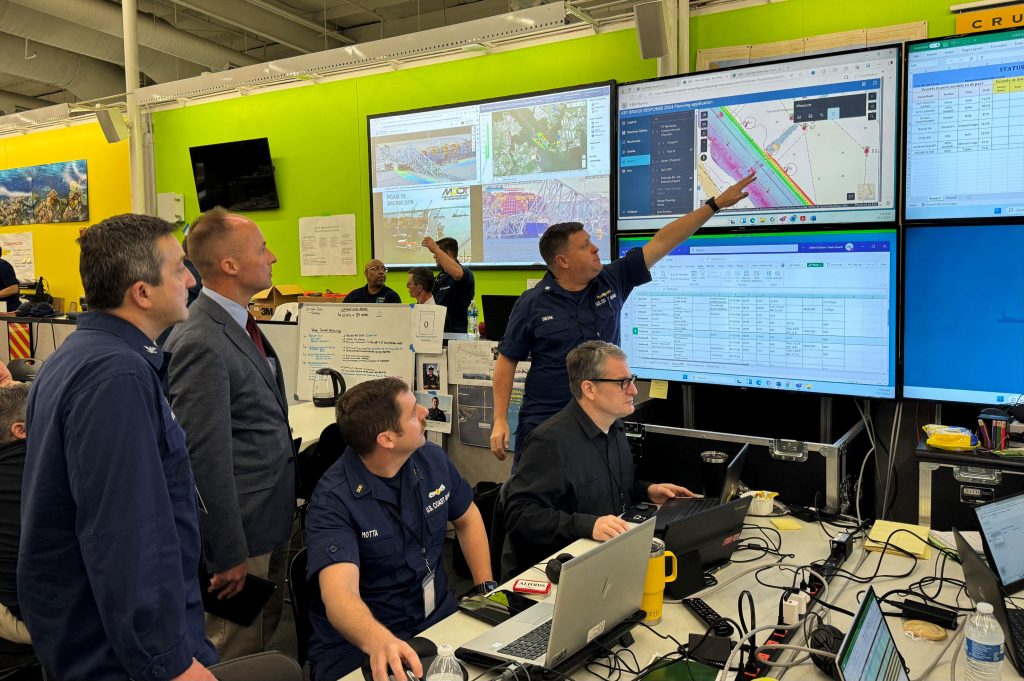
Underpinning the United Command Center effort is ArcGIS software provided by Esri, a longtime software provider to the U.S. Coast Guard.
Among other things, the software has enabled live, continuous monitoring of the salvage operations through the Key Bridge Response Hub. Throughout each day and night, several dashboards depicting live vessel positions and safety information are displayed to everyone involved in the response.
“The Key Bridge Response Hub and its simple interface … has removed antiquated data sharing challenges and sped up the rate at which our response partners have been able to share data, find data, analyze it and visualize it,” said Amilynn Adams, a member of the Response GIS Support Team at the Coast Guard’s Navigation Center in Alexandria, Virginia.
“There’s no doubt that the work to stand up the Hub has paid dividends in terms of the ability to provide spatial data products that enabled response decision makers to move quickly and with confidence to safely reopen alternate channels to commerce,” Adams said.
USCG Lt. Commander Ian Hanna, lead of the Response GIS Support Team, said, “Sharing complex hydrographic survey data in a cloud environment on the Coast Guard’s ArcGIS Online Federal State Local Tribal Parties portal was essential to opening the temporary channels quickly.
“Before we established the partnered collaboration each agency was looking at only their own data on printed maps,” Hanna said. “Visualizing all the data together in a web GIS environment allowed us to put all the pieces together and enabled agencies to interact with the data in a way that isn’t possible on printed maps.”
As for the live feeds, Hanna said the common operating picture dashboard has allowed the Incident Command Post to actively monitor the safety and progress of operations on the same web-map.
“Without ArcGIS Online they would have to reconstruct the same picture from VHF radio reports,” he said. “The ability to monitor vessels on the scene through an AIS feed and also to see live updates on dive operation status directly from the salvors on the same online dashboard has enhanced the safety and efficiency of the response.”
“The ArcGIS Online based GIS planning and monitoring tools used during the Key Bridge Response have truly been a force multiplier,” agreed Fredrick Dolbow, port security specialist for the Coast Guard’s Maryland-National Capital Region.
“It has provided us with the ability to combine geospatial data from various sources in many different formats, quickly process and analyze this data, and make informed operational decisions based on these results,” he said.
“The time it took to support safe, commercially essential vessel traffic transits through the affected area is remarkable and could not have been done as quickly and efficiently without this tool,” Dolbow added.
End Game for Response Effort
If all goes to plan, the partners in the response effort hope to reopen the permanent, 700-foot-wide by 50-foot-deep federal navigation channel by the end of May, restoring port access to normal capacity.
The next crucial step in the recovery will be the refloating of the Dali, which was pinned to the bottom of the Patapsco River by the large section of the bridge that came to rest on its bow.
Earlier this week, crews used explosive charges to break up the bridge section, though a portion of it remains. Testifying before a congressional committee on Wednesday, Coast Guard Vice Admiral Peter Gautier said the current expectation is the vessel will be refloated and removed from the site early next week.
The U.S. Army Corps of Engineers’ Bobby Petty said once the Dali is moved, the agency will fully dredge the navigational channel, removing close to 101 million cubic yards of material.
“That mission will continue at least a couple of months after the boat is floated,” Petty said.
NOAA too expects to be busy in the near term, not just because the Dali’s hull impacted the river bottom during the bridge collapse, but because sand and silt has been building up against it since the incident occurred eight weeks ago.
“We expect to do multiple surveys once the Dali is removed, and additional surveys after that, after each piece of the bridge is removed,” an official with the agency said. “It’s definitely going to be a long haul in regard to that survey work and ensuring the entire waterway is safe again.”
As for the rest of the response team, the Unified Command’s transition plan calls for it to start shrinking, footprint-wise, once the Dali is refloated and taken back to port.
After that, the entities comprising the response and recovery team will continue to reduce the number of staffers on hand, essentially going back to their normal day-to-day operations and dissolving the incident command post in the process.
With that, the Coast Guard and its state and federal partners in the effort will begin the after-action reporting process.
In regards to the Coast Guard specifically, the carefully archived notes and data collected during the response will be entered into a contingency planning system database so that anyone in the service, from headquarters on down to field level, will have them as a reference.
“Much like what happened after the Deepwater Horizon [explosion in the Gulf of Mexico], where area contingency plans were rewritten, there may be a whole rewrite down with our port partners to make sure we’re prepared should a situation like this, or something similar, occur in the future,” one official said.
“As far as the GIS collaboration in particular, this is a conversation that’s already started; we’re all looking at how we can expand this and grow it into something that’s normal operating procedure,” the official said.
If there’s a positive to be drawn from Key Bridge collapse, the official suggested, it is how the response has positively impacted the way disparate agencies work together and share and distribute marine safety information, and how they’ll ultimately get that critical information into the hands of the general public.
For more on the GIS collaboration and the Key Bridge response effort, please visit here.
Dan can be reached at [email protected] and at https://twitter.com/DanMcCue